GIS for Campus Planning: A Case Study at Clarkson University
University or college campus planners, does this story sound familiar to you?
Clarkson University’s main campus spans 640 acres, featuring a variety of academic buildings, residence halls, research facilities, and athletic events spaces. The Clarkson community depends on its facilities team, led by the Director of Facilities and Construction Michael Tremper, to maintain each path, parking lot, drain, fire suppression system, and so much more—all without exceeding annual budgets.
Clarkson’s facilities team is highly organized, as any group responsible for maintaining thousands of assets should be. Michael and his team must often weigh the cost of repairing or replacing a piece of equipment against the risk of waiting, a formula known in the architecture and engineering world as “business risk.”
On top of everything, Michael and his team need to communicate clearly with other campus personnel, contractors, and the public to demonstrate that any repair work is necessary, within budget, and completed properly.
A facilities team’s work is complex and important. That’s why Clarkson University, with the support of campus leadership, partnered with C2AE in 2023—to explore how geographic information system (GIS) technology can make campus planning simpler, faster, and more defensible.
If your campus could benefit from GIS technology like Clarkson University’s has, reach out! We’d love to schedule a demonstration.
The Power of GIS
GIS is a cloud-based software that connects spatial data to an aerial map with unlimited descriptive information.
To understand how GIS can benefit you, let’s imagine you’re responsible for maintaining three assets in a university building: an air conditioning unit, a security system, and an electrical control panel.
First, you’ll want to take pictures of all three assets, study their condition, and review any of the university’s records (such as the installation date or any past repairs). From there, you can create a GIS database with the assets’ photos, historical information, an estimate to repair or replace each asset, and the business risk of deferring maintenance. It’s helpful to have a GIS specialist guide these tasks.
With your GIS now built, you can easily view and edit all that data from a map on your phone or tablet. You can also add more assets into the GIS later on; it scales up with ease.
Any of your future maintenance plans will be easy to share with coworkers and defend to departments with competing needs. Plus, when you eventually retire, your successor will have the information they need to keep everything running smoothly.
GIS at Clarkson University
For all these reasons, C2AE and Clarkson University are building a GIS database, beginning with the school’s four-story Center for Advanced Materials and Processing (CAMP) building.
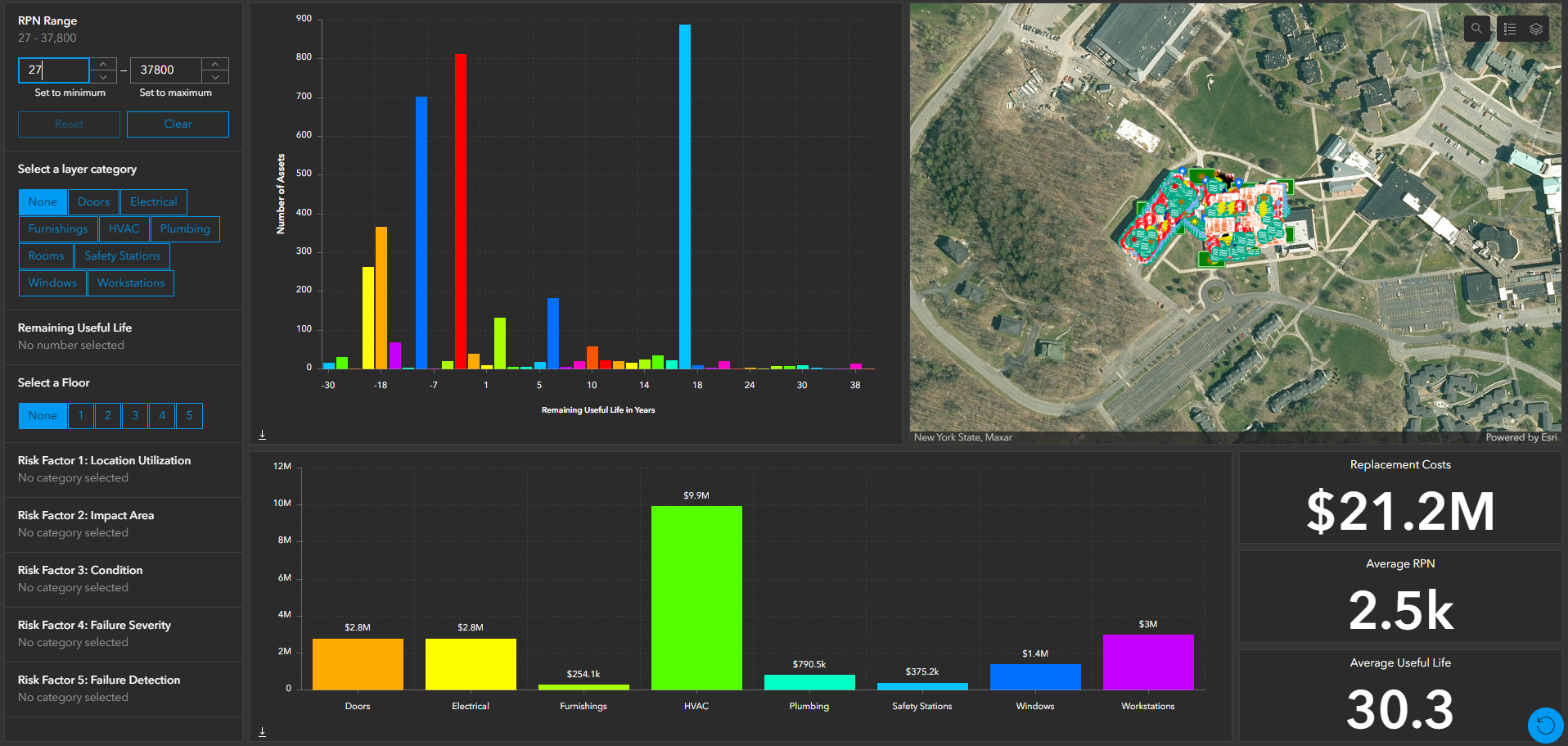

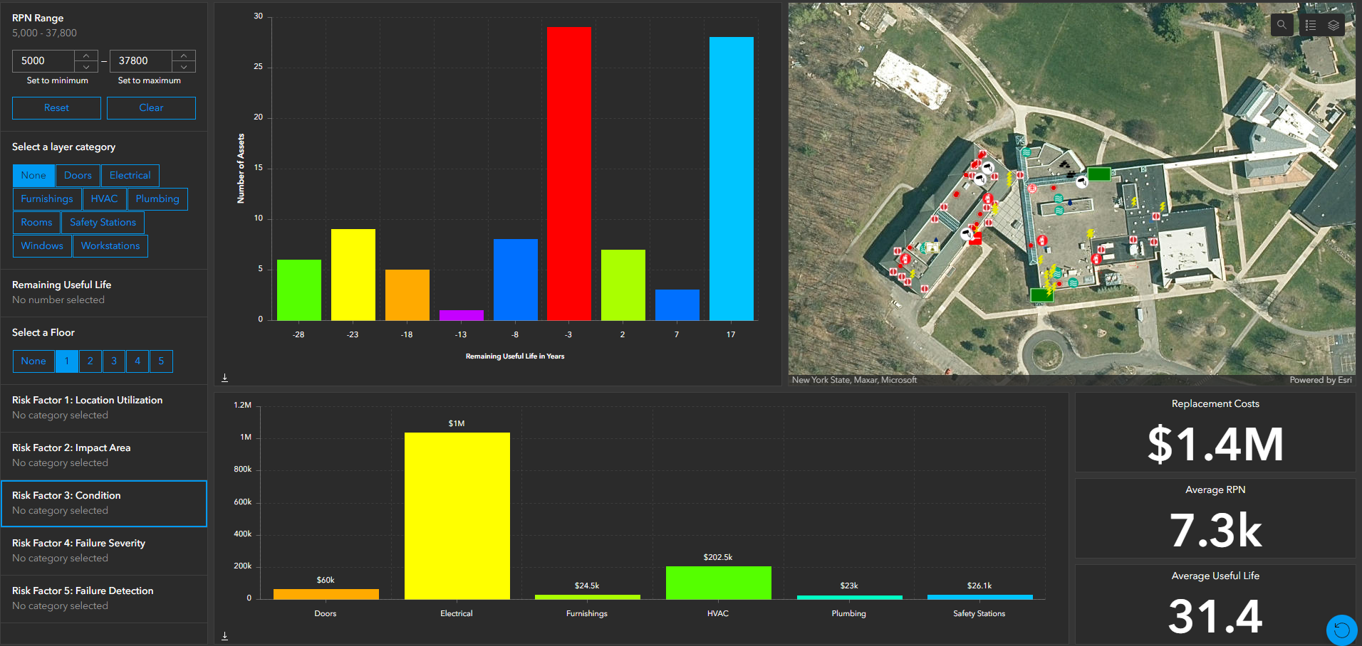
With the help of Patrick Hayes, an engineering intern and Clarkson graduate, C2AE methodically assessed and recorded equipment from every office, mechanical room, classroom, and laboratory.
When asked whether he would recommend this process to other universities, Hayes answered: “Definitely…Coming into this as a former student, I know the rooms where the air conditioning units are working too hard—because I’ve taken classes there. It’s hard to learn about thermodynamics in a hot room. So, I can say from experience that this process is going to help Clarkson University and its students.”
Once the GIS is complete, Michael Tremper and the Clarkson facilities staff will be able to access and update every piece of data C2AE collected. Over time, maintenance will become simpler. The CAMP building will become more efficient. The university will be able to put the money it's saving on energy and maintenance elsewhere on campus.
We at C2AE look forward to seeing this technology revolutionize campus planning at Clarkson and campuses everywhere.